Drone Survey Services in Delhi, Noida & Gurgaon

A project team often needs a site view that is easier to interpret than scattered ground measurements. drone survey in Delhi, Gurgaon and Noida can provide aerial mapping for large sites, corridors and development areas where a visual record adds value.

In Delhi NCR, dense urban areas and the Yamuna floodplain create different site conditions. For infrastructure, mining, industrial and real-estate work, aerial data can help teams review existing conditions, progress and quantities while keeping the survey tied to ground control.

What Is a Drone Survey and Why It Matters

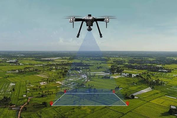
A drone survey uses planned aerial photography to capture overlapping images of a site. Those images are processed into outputs such as an orthomosaic, terrain models and contours, creating a measurable visual representation of the surveyed area.

For a project manager, the benefit is coverage. Large or difficult-to-reach areas can be captured without relying entirely on point-by-point ground observation. DGPS ground control points help connect the aerial dataset to the project’s coordinate framework.

drone survey in Delhi, Gurgaon and Noida, Noida & Gurgaon: Terrain, Projects and Challenges

Drone survey company Delhi

Delhi’s built-up environment can make aerial work dependent on careful flight planning and available airspace. The Yamuna floodplain presents a different open-ground context, but project teams still need to consider permissions and site conditions. For infrastructure and real-estate work, aerial mapping can support progress views, site understanding and volume-related tasks.

Drone survey in Noida

Noida’s large development parcels and planned infrastructure can create useful applications for aerial mapping. A drone survey in Noida may help a team review broad construction areas, prepare visual base information or assess earthwork volumes. A drone survey company Noida can plan the aerial capture around the site’s intended output. Ground control points remain important where the aerial outputs need to align with the project’s coordinate system.

Drone survey in Gurgaon

Gurgaon combines dense construction with expanding development areas, so the usefulness of aerial coverage depends on the site’s size, surroundings and flight conditions. For Gurgaon projects, drone mapping can create an aerial record for progress or large-area assessment. Weather and airspace conditions must be considered before a flight is planned.

Our Drone Survey Process, Step by Step

Equipment and Technology

Survey drones capture overlapping aerial images along planned grids. DGPS ground control points support the spatial reference, while CAD is used for the project base plan. An orthomosaic is a corrected aerial image assembled from many photographs. A DEM or DTM represents terrain digitally.

Deliverables You Receive

Industries and Projects We Serve

Zenith supports EPC contractors, consultants, developers, landowners and government departments working on large townships, industrial and corridor projects, mining, progress monitoring, earthwork and real estate. The right aerial output depends on the site’s size, terrain and the project team’s intended use.

Cost Factors

The drone survey cost Delhi projects involve depends on the area to be covered, required image resolution, number of DGPS ground control points and terrain. A larger or more complex site can require a different flight and control plan.

Permissions are another factor. Airspace conditions and site restrictions can affect flight planning, while weather can influence when field capture is practical. Zenith checks these requirements before flying.

Why Choose Zenith Consultancy

Zenith Consultancy is a drone survey company Delhi project teams can engage when aerial mapping is appropriate. Our drone survey services Delhi</b include teams travelling to site, a method set to the accuracy the design needs and data checked against reference points where relevant.

For larger projects, data can be handled in stages. We provide plain-language reporting and files ready to use. Drone flights follow applicable DGCA requirements and the Digital Sky platform, with permissions checked before flying.

Frequently Asked Questions

What affects the cost of a drone survey?

The main factors are area, required resolution, number of ground control points, terrain and permissions. A broad open site and a constrained built-up area can require different planning. The required deliverables also matter because the project may need only aerial mapping or additional contours, terrain models and volume calculations.

The field and processing effort depends on the area, flight planning, terrain, required outputs, weather and airspace conditions. Permissions can also affect when a flight can proceed. Zenith reviews these factors before field work so the planned capture matches the project scope rather than assuming a fixed schedule.

Aerial coverage in Delhi is most useful where it can add value to a large site, progress review or volume-related task. Dense surroundings and airspace conditions require careful planning. A drone survey company Delhi project team should therefore check the proposed flight area and applicable permissions before capture.

For drone survey in Noida, the project team should define the area, required resolution and intended outputs before flight planning. Large development sites can benefit from aerial coverage, while DGPS ground control points help relate the imagery to the survey framework. Airspace and site conditions must also be checked.

Drone survey in Gurgaon can suit large construction or development areas where an aerial record, terrain model or volume calculation is useful. A drone survey company Gurgaon can review the flight area and required output before capture. The site must still be assessed for surrounding development, weather and airspace conditions.

Request a Quote

For drone survey in Delhi, Gurgaon and Noida, share the site location, area or corridor length and required deliverables. Call or message Zenith Consultancy so the flight, control and processing scope can be reviewed.

Sign up to Privitar’s weekly newsletter to get the latest updates.

We don’t send you any spam

Copyright © Gerow| All Right Reserved