Brochure

when an unknown printer took ga lley offer typey anddey.

PDF. Download DOC. Download

If You Need Any Help Contact With Us

+91 9717087858

Get A Free Quote

    Contour Survey Services in Shimla & Kullu

    At the end of a contour survey in Shimla or Kullu, you hold a map showing how the ground rises and falls, with lines drawn at the interval your designer needs. That map shows where to cut, where to fill and where water will run. Zenith Consultancy serves developers, EPC contractors, consultants, landowners and government departments across the region.

    Our teams measure your site, process the levels and deliver a map your designer can use directly. This page explains what the survey records, how steep ground affects it and what you receive.

    What Is a DGPS Survey and Why It Matters

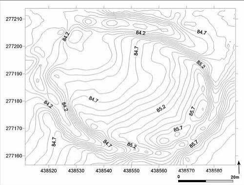
    A contour survey records ground elevations and draws lines that join points of equal height. Where lines sit close together the slope is steep, and where they spread out the ground is gentler. Designers use the map to plan grading, drainage, roads, foundations and earthwork quantities.

    For a project manager, good level data reduces surprises during excavation. The same points can also form a digital elevation model (DEM) when a design team needs one.

    Contour Survey in Shimla & Kullu: Terrain, Projects and Challenges

    Shimla

    On steep Himalayan slopes, contour lines sit close together, so the survey needs enough points to show every change in gradient. In Shimla, building plots and hill roads rely on this detail for terracing, drainage and retaining structures. Dense trees or walls can limit the view, so we plan the grid around them. The map shows ground levels only, and stability checks belong to qualified engineers.

    Kullu

    A contour survey in Kullu may support hill roads, hydro works and tunnel approaches where levels decide the alignment. Along a valley, drainage and stream edges strongly affect design, and contours show where water will flow. Cross sections cut through the contours at chosen points to give designers exact profiles. Kullu sites often need more field time than flat land, because moving across slopes is slow.

    Our DGPS Survey Process, Step by Step

    Equipment and Technology

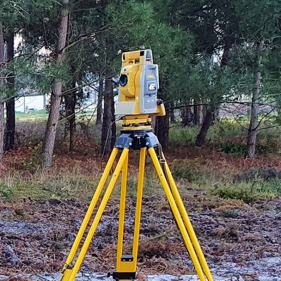
    We use Total Station and DGPS levelling, depending on the site. A Total Station suits slopes with walls and trees, while DGPS suits open ridges. Processing software builds the ground surface, and CAD software draws the contours. Steeper ground often uses a larger contour interval, and your designer decides the interval.

    Deliverables You Receive

    Industries and Projects We Serve

    We work with developers, EPC contractors, consultants, landowners and government departments. In Shimla and Kullu, common uses include terracing and drainage plans for building plots, level data for hill roads, and ground information for hydro and tunnel works. Consultants preparing a DPR may also need contours to show the existing slope before design begins.

    Cost Factors

    We do not use a flat rate for every site. When you compare quotes for contour survey cost Shimla projects, check what each one covers.

    Price depends on the area, the contour interval and the density of survey points, which rises on steep ground. Vegetation, access and extra outputs such as cross sections or volumes also matter. Send us the location, area and brief for a quotation.

    Why Choose Zenith Consultancy

    A contour survey company Shimla clients rely on should match its survey grid to the design, not the other way round. Zenith Consultancy works this way.

    We deliver contour survey services Shimla and Kullu projects can use, with plain-language notes.

    Frequently Asked Questions

    What affects the price of a contour survey on a hill site?

    Price depends on the area, the contour interval, the number of points needed on steep ground, vegetation and access. We do not use a flat rate. Send the location, area and design brief, and Zenith Consultancy will share a written quotation.

    Time depends on site size, slope, interval, access and weather. Steep ground and dense vegetation slow field work. We confirm a schedule in the quotation, and larger sites can receive data in stages. Tell us your design deadline, so we can plan the field work to match.

    Your designer’s requirement decides it. As a general guide, steep ground often uses 1 to 2 m or more, while gentler land uses a smaller interval. Share the interval or the design brief, and we will set the survey grid to match your designer’s needs.

    Yes, Zenith works as a contour survey company Kullu clients can brief directly. We record levels along the corridor and deliver a CAD contour map with spot levels and cross sections on request. Share the route and interval for a quotation.

    A contour survey focuses on ground levels and slope. A topographical survey maps levels together with roads, buildings, trees, water and boundaries on one plan. If your designer needs only levels, a contour survey may be enough. Ask your consultant which scope applies.

    Request a Quote

    Planning a contour survey in Shimla or Kullu? Share your site location, area, preferred contour interval and the deliverables you need. Call or message Zenith Consultancy, and we will respond with a quotation.

    Sign up to Privitar’s weekly newsletter to get the latest updates.

    [mc4wp_form id=310]

    We don’t send you any spam

    Copyright © Gerow| All Right Reserved

    Zenith Consultancy provides survey and site investigation services for buildings, railway, highway, dam, transmission line and all types of Infrastructural projects.

    Copyright © 2026 Zenith Consultancy